|
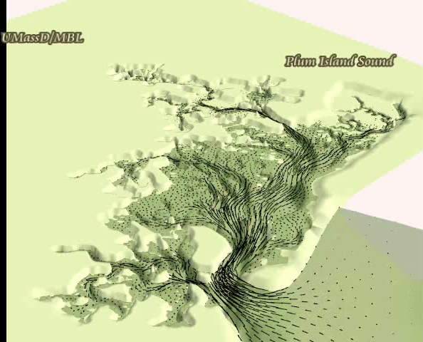
Here is a simulation showing
velocity field and flooding and drying of
the marsh platform. The marsh topography data were obtained from a
LIDAR flyover. Bathymetry data are based on GPS surveys of tidal creeks
combined NGDC bathymetry surveys.
Click image on left to
download and AVI movie
file. The simulation uses an older modeling domain that does not
include the Merrimack River and its connection to PI Sound via PI
River. File is 12.6 MB. |
| The simulation (on right) shows
salinity and tidal elevation along a 2D transect (depth vs length)
through the Parker River and Plum Island Sound. These simulations were
compared to CTD transects, which were used to assist in model
calibration. Fresh water forcing enters via the Parker River (at
left in simulation). Due to high tidal energies and shallowness of the
estuary, the estuary does not exhibit much vertical stratification as
evident in the simulations. Fresh water inputs from other rivers are
also included in the whole simulation. File is 53 MB. |
 |
 |
This simulation (on left) shows
velocity and salinity in a 2D cross section taken at the Southern mouth
of Plum Island Sound. The perspective is from the Gulf of Maine
looking into the Sound. Velocities along this and several other
cross sectional transects along the Parker River, Ipswich River, Rowley
River, Plum Island River, Eagle River and Sound were compared to ADCP
surveys to verify model prediction skill. File is 60 MB. |
| This simulation (on right) shows
particles released at various locations within PIE and the Merrimac
River at maximum flood velocity. Note the particles leaving the
Merrimac River can be entrained into the Sound, and particles in the
Sound can be exported to the Merrimac via the Plum Island River.
Analysis of residual currents shows that a large clockwise circulation
develops from PI Sound heading north into the Merrimack River via PI
River, then onto the shelf from the Merrimack River mouth where it then
travels southerly along the shelf before being entrained back into PI
Sound via the southern mouth. File is 45.8 MB. |
 |
 |
The simulation (on left) shows
how salinity changes over several tidal cycles across the entire
estuarine-river-shelf complex. Note that during flood tide a
large bolus of fresh water in the Merrimack River gets injected into
the northern part of Pl River. File is 6 MB. |
 |
 |